Solution
Underwater Drone
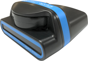
Tethys one
Pioneering Autonomous Exploration in Rivers and Tidal Currents – Unveil the Future of Underwater Drone Inspections for Challenging Environments.

Specifications
(no add. equipment needed)
stationary inspection
(extendable)
(hot-swappable batteries)
Main Features

Autonomous Operation
- autonomous & repeatable area coverage/structure scanning
- position & orientation hold
- depth and distance lock to ground and objects
360º terrain awareness
- omnidirectional movement control 360º in roll, pitch, and yaw
- DVL, side- and front-facing sonar sensors for 360º awareness
- terrain following
- obstacle awareness


positioning in strong currents
The drone enables autonomous operation capability by empowering operators to define search areas and set waypoint markers, enabling a seamless and autonomous inspection of complex underwater structures.
- stationary inspection work in water currents up to 3.5 knots
- operation in rivers and offshore tidal currents.
Intuitive manipulation
- 3D manipulation & grabber
- underwater lifting capacity: equivalent of one fully equipped diver
- allows new operators to effortlessly manipulate and interact with the environment


Recording & reporting
- 3D mapping in poor visibility
- user-friendly Tethys UI with mini-map
- 100º tiltable full HD cameras & front-facing multibeam sonar
- placing points of interest (POI) any time
- live recording and reporting during mission
- post-processed photogrammetric & bathymetric 3D models enabled


Modularity
Tethys One is a ready-to-use underwater drone, complete with a standard sensor package that guarantees advanced navigation and mapping capabilities.
Moreover, our underwater drone has the capability to bear diverse payloads and seamlessly integrates with environmental sensing, manipulation, or high-precision scanning functionalities. Enhance your 3D models by incorporating environmental data such as metal detection, current, pressure, temperature, oxygen levels, thickness, non-destructive testing (NDT), and beyond.
Click the payload tools


Our piloting sonar, mounted on a tiltable head alongside the stereo cameras, allows the pilot to view both in front of and below the ROV, even in zero-visibility conditions.
Specifications:
The Blueprint Subsea M-Series sonars, M750d, M1200d, and M3000d, mainly differ in range and image detail. All models share the same compact housing, and 500 m depth rating.
- The M750d is the most versatile, offering long-range performance (up to 120 m) and clear imaging for navigation and general inspection.
- The M1200d provides higher resolution but shorter range (around 40 m), ideal for detailed structural or hull inspections.
- The M3000d delivers the sharpest, most detailed images at very close range (up to 30 m), making it perfect for precision tasks like target identification or search and recovery.
DVLs (Doppler Velocity Logs) enable accurate underwater navigation, altitude maintenance, and real-time velocity measurement by analyzing Doppler shifts from acoustic signals reflected off the seabed. Additionally, they can assess current profiles for flow analysis.
.png)
Specifications:
- The Nucleus 1000 is a compact, cost effective, sensor hub combining a Doppler Velocity Log (DVL), inertial sensors (AHRS), altimeter, pressure and temperature sensors in one package. It can perform bottom-tracking (altitude to seabed) from about 10 cm up to 50 m, estimate velocity, attitude, heading, and also perform water-tracking and current profiling functions. It is depth rated to 300 m in its default version (with a deeper rated version available).
.png)
- In contrast, the DVL 500 Compact is more focussed on high-accuracy Doppler velocity measurement and bottom-tracking as its primary role. It supports bottom-track from 0.1 m up to 175 m and is depth rated to 300 m. It also supports water tracking, current profiling, and has built-in sensors like pressure and temperature, but it lacks the full integrated inertial / attitude / heading sensor suite that the Nucleus provides
Our navigation unit combines dual GNSS sensors with an Ultra-Short Baseline (USBL) positioning system to provide precise localization and accurate heading estimation for the Tethys ONE. Using acoustic signals, it measures underwater depth and precisely determines the ROV’s global position. The system’s flexible design allows it to be mounted on nearly any vessel, fixed structure, or platform, and it can also be configured for use by nearby divers.
%20250%20-%20CC3%20(rotataed).png)
Specifications:
- The Blueprint Subsea SeaTrac Standard is a real-time and precise underwater acoustic positioning system combining an X150 USBL beacon and an X010 modem beacon, capable of localizing our Tethys Robotics systems.
- Position displayed in real time.
The multibeam echosounder captures the data used to generate 3D bathymetric models using our advanced localization, both in real-time and during post-processing.
.png)
Specifications:
- This 240 kHz multibeam echosounder featuring a 4° along-track and 80° cross-track transmit beam. Designed for high-resolution mapping and inspection, and is ideal for Tethys ROV systems and shallow-water survey operations.
- Depth-rated to 300 m, it achieves effective survey depths of up to ~50 m, and more in favorable bottoms such as hard sand, rock, or compacted sediment.
- Provides real-time 3D mapping capability.
CP Probe: contact probe that provides a means of carrying out underwater cathodic protection potential measurement.
%20Cropped.png)
Specifications:
- The cathodic protection contact probe to be easily mounted on the Tethys ONE, enabling live CP potential measurements on submerged assets such as hulls, pipelines, and sacrificial anodes during navigation.
- It is an Ag/AgCl half-cell CP probe with an accuracy of ±5mV.
- Measured potential is displayed in real time on the Tethys user interface (GUI).
The Cygnus Mini ROV-Mountable UT Probe is an ultrasonic thickness gauge that is supported by the Tethys ONE. Using a multiple-echo technique, it accurately measures metal thickness through coatings without the need to remove paint or insulation. This probe is ideal for in-service inspection of ship hulls, offshore platforms, pipelines, and other subsea structures, enabling operators to efficiently assess corrosion and remaining wall thickness while the ROV navigates underwater.
.png)
Specifications:
- Depth rated to 500 m.
- It measures steel thicknesses from approximately 3 mm to 250 mm (depending on probe frequency), with an accuracy of ±0.1 mm.
- Thickness measurements are displayed in real-time on the Tethys user interface (GUI).
The cavitation cleaning system consists of a zero-thrust cavitation cleaning lance, a neutrally buoyant high-pressure hose, and an electric high-pressure unit.
.png)
Specifications:
- Zero Thrust Lance: Max. working pressure 300 bar (4350 psi) / Maximum flow 80 LPM (21 gpm) / SIR certified / Lance length 680 mm / Retro lance length 225-435 mm
- High Pressure Hose: Neutrally Buoyant / Up to 100 m / Quick-connect couplings
- Electric High Pressure Unit: 8.8 kW / 400VAC 3-phase / 4 wheels with air tyres / Max. pressure 21 LPM at 250 bar (5.5 gpm at 3625 psi) / 161 kg / 900x750x950 mm
The 3-axis manipulator enhances versatility and precision by providing multi-directional control, allowing for intricate and efficient handling of objects in various applications.
%20Cropped.png)
Specifications:
- Reach Alpha manipulator arm is a compact, all-electric underwater robotic arm, offering approximately 0.4 m reach, a lift capacity of 2 kg at full extension, 600 N closing force, and joint positioning accuracy of 0.1°, using fully sealed actuators for reliability in harsh environments.
- Weight in water: approx. 0.9 kg / Depth rated to 300 m
Underwater Metal Detector: It is an essential toolfor marine missions, utilizing electromagnetic fields to accurately locatemetal objects beneath the water's surface.
Specifications:
- Depth rated to 300 m / Detects magnetic and non-magnetic metals / Very high sensitivity / Not affected by mineralized soils / Maximum ROV speed with system installed: 1 knot (0.5 m/s) / 1330 × 584 × 100 mm.
- Measurements displayed in real time on the Tethys user interface (GUI).
Magnetometer: It is a key instrument used to detect ferromagnetic materials such as iron, steel, and nickel beneath the ocean surface. It is commonly used to locate submerged ammunition.
Specifications:
- Measurements displayed in real time on the Tethys user interface (GUI).